
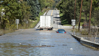
Increased Flooding Caused By Climate Change Will Be Worse In Small Watersheds
By A'ndrea Elyse Messer, Penn State News
Understanding how climate change will affect the flooding of rivers may become easier with a new framework for assessing flood risk that's been developed by an interdisciplinary team from Penn State.
"New home builders want to know how high they have to put their buildings to be safe for the future," said Alfonso Mejia, associate professor of civil and environmental engineering. "They want to know how the flood zones are going to change in the future."
The Federal Emergency Management Agency issues flood maps for areas near rivers, but according to the researchers, FEMA does not update its maps frequently, nor does it project the future potential impact of climate change on how areas will flood.
FEMA flood maps are based on historically observed flood records, not future possible events.
"FEMA does a good job in mapping flood hazards, but the part we are incorporating is the future climate so we can understand the impact of climate on flood hazards and exposure," said Mejia.
The researchers, who published their results in the Journal of Hydrometeorology, considered a wide array of variables in their framework, including meteorological, hydraulic, hydrologic, topographic and others.
"The data and models required to project flood hazards and exposure come from diverse academic disciplines and they must be integrated and compatible," said Sanjib Sharma, assistant research professor in the College of Earth and Mineral Sciences' Earth and Environmental Systems Institute.
Flood maps are usually drawn to show the 100-year flood inundation boundary, a flood that has a 1 percent chance of hitting an area in any given year.
The researchers note that while they are producing 100-year maps, they also can produce 500-year maps.
They also say that as time and climate change progress, the 100-year flood maps change as well. The map for 2050 is different from the map for 2100.
The researchers did a regional analysis to assess flood hazards and exposure across all the cities and boroughs in Pennsylvania.
"It's a really complicated process and the geoscientists and engineers need to link with the policy and insurance people at all levels," said Mejia.
The framework combines climate model outputs for a hydrologic model that creates streamflow projections.
The streamflow projections are joined with a hydraulic model and a statistical model to map the uncertainty of flooding during extreme flooding events.
The researchers report that climate uncertainty dominates the overall uncertainty surrounding the flood inundation projection chain. The combined hydrologic and hydraulic uncertainties account for as much as 37 percent of the total uncertainty.
The study also found that in all of Pennsylvania, when accounting for changes that climate change will make, the areas that will be prone to flooding in the future are mostly the same areas that are prone to flooding now.
Also, flooding peaks due to climate change will be worse for small basins.
The researchers also warn that "assuming a stationary climate can underestimate regional flood risk."
"We know what the problem is, and where, but it is the severity of the problem that we don't know," said Sharma.
Also on the project from Penn State were Klaus Keller, professor of geosciences; Robert Nicholas, associate research professor of atmospheric sciences; and Michael Gomez, postdoctoral fellow in civil and environmental engineering.
This work was supported through the Penn State initiative for resilient communities by a strategic plan seed grant from the Penn State Office of the Provost, with co-support from the Center for Community Design, and by the National Oceanic and Atmospheric Administration through the Mid-Atlantic Regional Integrated Sciences and Assessments program.
(Reprinted from Penn State News.)
Underestimating Flooding Risks From Climate Change Can Lead To Poor Infrastructure Design
A new paper by Penn State researchers found underestimating flooding risks from climate change can lead to poor infrastructure design without incorporating safety factors.
Sanjib Sharma, assistant research professor in the College of Earth and Mineral Sciences' Earth and Environmental Systems Institute, and his team found current approaches to design flood-sensitive infrastructure typically assume a stationary rainfall distribution and neglect many uncertainties.
These assumptions are inconsistent with observations that suggest intensifying extreme precipitation events and the uncertainties surrounding projections of the coupled natural-human systems.
The authors show that assuming climate stationarity and neglecting deep uncertainties can drastically underestimate flood risks and lead to poor infrastructure design choices.
The study found that climate uncertainty dominates the socioeconomic and engineering uncertainties that impact the hydraulic reliability in stormwater drainage systems.
The paper quantifies the upfront costs needed to achieve higher hydraulic reliability and robustness against the deep uncertainties surrounding projections of rainfall, surface runoff characteristics, and infrastructure lifetime.
Depending on the location, the paper found that adding safety factors of 1.4 to 1.7 to the standard stormwater pipe design guidance produces robust performance to the considered deep uncertainties.
The insights gained from this study highlights the need for updating traditional engineering design strategies to improve infrastructure reliability under socioeconomic and environmental changes.
Click Here for a copy of the research.
Related Articles:
-- PA Will Experience 42% More Days Of Extremely Heavy Precipitation By 2050 Due To Climate Change
[Posted: November 21, 2021] PA Environment Digest
No comments :
Post a Comment